Introduction
The Rivelin Valley nature and heritage trail is a scenic 3 mile (c. 5 km) walk upstream along the lower reaches of the Rivelin valley, starting from Malin Bridge and ending at Rivelin Corn Mill (Rails Road). At an easy pace the walk should take between 1½ and 3 hours (excluding return), depending on time taken to look for wildlife and the historical remains.
The trail is not waymarked but is fairly easy to find as it follows the river. Return via the same route or using some of the many other footpaths and lanes in the area; alternatively, return by walking for 20–30 minutes up to Lodge Moor, Crosspool or Stannington, from where there are regular buses to Sheffield city centre.
For more details about how to find the trail, accessibility and facilities.
The trail can be enjoyed at any time of the year. It has open access for public recreation and attracts many Sheffield residents as well as visitors from outside the City.
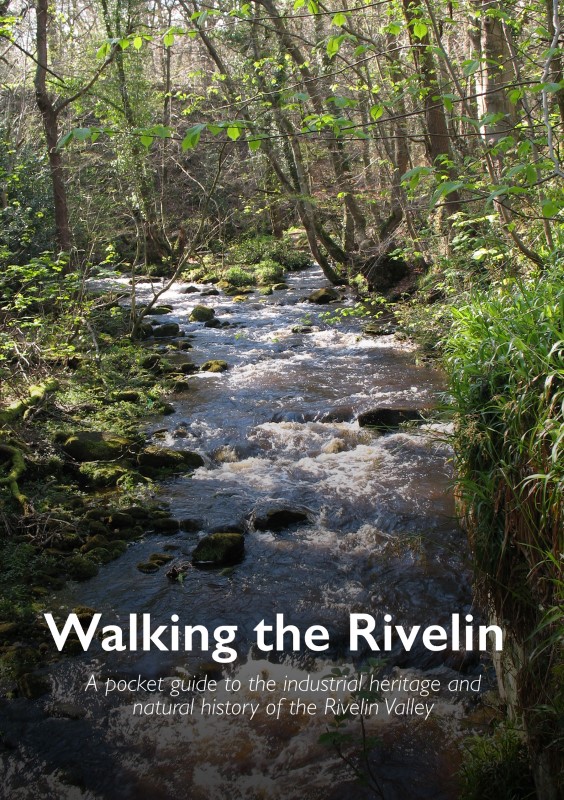
A book ‘Walking the Rivelin’ is available to guide you through this beautiful valley, with maps and historical details about each watermill site and notes on where to look for the wildlife. It is richly illustrated in colour with old photographs and maps, for details of where to purchase the book.
Details of the individual mill sites can be found on our site, use the menu links above to navigate to different sections of the trail. While on the trail, look out for a series of interpretation posts and use the QR Codes and NFC tags to link to the detailed information provided on this website.
Footpaths and access
The trail can be started at Malin Bridge or Rails Road. It is not waymarked but it follows the river. Shorter circuits can also be enjoyed. Please explore, enjoy and relax in the valley, but respect the environment and archaeology so others can also enjoy it, by following the Countryside Code – keep dogs under control (and preferably out of the water), bag and bin dog poo (even if not on or near the path), take litter home if bins are full.
Bicycles and horses are not permitted on the footpaths, but on bridleways walkers share with horses and bicycles.
Accessibility
Mostly easy walking alongside the river, especially in the first half of the trail from Malin Bridge to Glen Bridge (‘S-Bend’). There are some steps, stepping-stones and narrow paths in the south-western stretch between Glen Bridge (the ‘S-bend’) and Rails Road. Some paths can become a little muddy and slippery after heavy rain. In order to complete the trail, three quite busy roads must be crossed. The trail is not suitable for mobility scooters.
Disabled facilities are available at the toilet block next to the Rivelin Park café at Spooners Wheel.
The Rivelin Water Play area (open during the summer) is accessible to people of all abilities; special aqua wheelchairs are available for loan to disabled children and their carers. For more details see visit Sheffield Parks, Sport & Recreation.
Rivelin Valley Sculpture Trail
Rivelin valley on the north west edge of Sheffield contains the historical and archaeological remains of watermills. As the mills fell into disuse, the valley has slowly been reclaimed by nature and is now home to many birds, plants and animals living alongside the babbling waters of the Rivelin river. The sculpture trail was set up by RVCG in 2021 to highlight the public art found in the valley and for people to enjoy its natural setting.
Sculptures first made a appearance in the Rivelin Valley in 2011 with the installation of the by Sheffield City Council of the Rivelin Chair. This was designed and constructed by local artist Jason Turpin-Thomson. Made to look like a coppice wood seat it is actually made of cast iron to reflect the remains from the old mills and the twisted tree roots found covering the old dams. In 2021 RVCG marked its 30 th anniversary by commissioning a stone bench. Made by local sculptor Andrew Vickers of Stoneface Creative of Storrs Lane, Stannington it depicts a grinding wheel and anvil. On it are carved the tools once made in the Rivelin valley and birds and animals which live there. In 2022 Stoneface Creative was commissioned by RVCG to create a child friendly sculpture. This resulted in the ‘sleeping giant’ found in the Children’s play area.
The sculpture trail is suitable for all ages and is about 1.5 km in length. It should take around 20 minutes and is on easy-going trails. It starts in Rivelin Park opposite the Rivelin Water play area. Free on street parking is available on Rivelin Valley Road [S6 5GE] or it is a 20 min walk from bus and tram stops at Malin Bridge. After Stop 5, those with pushchairs or wheelchairs may want to return via Roscoe Bridge to avoid steps. For those who want to see more, the nature trail can be followed using well marked paths to Rails Road. Here a wildlife pond with a dipping platform has been planted up and a willow tunnel created.

What to see
The trail weaves along beside the river, passing through woodlands and pastures that are also important for wildlife. If you look carefully you will find many types of plants, trees, birds and animals, as well as historical and archaeological remains of 20 watermills and 21 mill dams – these date from the 16th to the 19th century and played a key role in the cutlery and steel industry of Sheffield [article about S Yorks Heritage listing]. The valley has slowly been reclaimed by nature since the mid-19th century as these rural industries declined and the watermills fell in to disrepair and were subsequently demolished.
The paths mainly pass through woodland, with trees such as Alder, Ash, Beech, Holly and Oak. Spring flowers include Bluebell, Cow Parsley, Dog’s Mercury, Stitchwort and Wood Sorrel. Birds such as Blackbird, Great tit, Long-tailed tit, Robin, Nuthatch, Treecreeper and Wren are regularly seen amongst the trees. Others such as Dipper, Grey Heron, Grey Wagtail, Kingfisher and Mallard can be found along the river or at the water-filled mill dams. At dusk look out for bats patrolling the river or flying low over the mill dams.
Route Maps for various walks in the Rivelin Valley
Click the image for more details


Where to see more of Sheffield’s industrial heritage
Abbeydale Industrial Hamlet: an 18th century rural scythe and steelworks on the River Sheaf. South-west Sheffield.
Kelham Island Museum: objects, pictures and archive material representing Sheffield’s industrial story, including a ‘Little Mesters Street’ and the working ‘River Don’ steam engine. Central Sheffield.
Shepherd Wheel: a restored 18th century waterwheel and grinding shop in the Porter Valley. South-west Sheffield.
Wortley Top Forge: 17th Century Iron Forge, the oldest surviving heavy iron forge in the world. North of Sheffield, near Stocksbridge.
Acknowledgements
A History of Sheffield. David Hey (2010). Carnegie Publishing.
Mousehole Forge. Richard A. Postman with John and Julia Hatfield (2003). Postma Publishing.
Reminiscing around Rivelin. Roy Davey (2005). DS Publishing.
The water-mills of Sheffield. W.T. Miller (1936). 4th edition (1949). Sheffield Trades Historical Society.
Water Power on the Sheffield Rivers. C. Ball, D. Crossley, N. Flavell (Editors). 2nd Edition (2006). South Yorkshire Industrial Society.
Where t’watter runs o’er t’ weir. A look back at Sheffield’s Watermills. Roy Davey (2008). DS Publishing.
Further information
To find out more about the individual sites, use the QR Codes and NFC tags located on a series of interpretation posts found along the valley. A book “Walking the Rivelin”, which describes the industrial heritage and natural history along the trail, is also available from this website, Rivelin café and other outlets.