Listen to Graham Appleby's song about the Rivelin Valley called “Messing about on the Rivelin”
Introduction
The Rivelin valley lies in the north-west of Sheffield on the eastern border of the Peak District National Park. The headwaters are high on the heather-clad Hallam Moors, from where the peaty water drains down into the river flowing north-eastwards to join the River Loxley at Malin Bridge. The Rivelin is one of the tributaries of the River Don, which flows through Sheffield and on through Rotherham and Doncaster, then out to the Humber Estuary and the North Sea.
Catchment Area
The Rivelin river catchment covers nearly 3000 hectares, with a varied landscape from the peace and tranquillity of the moors up by Stanage Edge to the busy suburban area of Malin Bridge some six miles to the east. The catchment is partly suburban (taking in parts of Lodge Moor, Stannington, Crosspool, Crookes and Walkley) and partly rural, with a wide variety of habitats including moorland, improved pastures, allotments and woodlands. The many footpaths around the steep-sided valley invite exploration of the countryside close to Sheffield and afford some wonderful views. With three Scheduled Ancient Monuments, 37 Grade II listed structures, Roman remains, a nature and heritage trail, and much more, there is plenty of interest to explore around the valley.
The western part of the catchment lies within the Peak District National Park. On the south side of the valley there are three nature reserves managed by Sheffield and Rotherham Wildlife Trust: Hammond’s Field, Wyming Brook and Fox Hagg. These are particularly noted for their bird life, including Lapwing, Curlew, Willow Tit, Crossbill, Redstart and Pied Flycatcher, as well as being home to a small population of water voles, which are now considered Endangered in the UK.
Redmires Reservoirs and Rivelin Dams were built in the mid-19th century to supply clean drinking water to Sheffield. For many years this has been supplemented by water brought through a tunnel from the Derwent valley to the west. The water is treated at the Yorkshire Water Rivelin Treatment Works (beside the A57), a new building for which was erected in 2018, partially buried under a ‘green roof’.
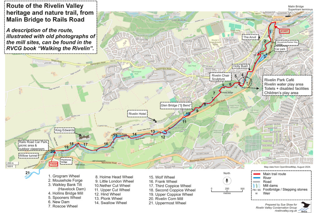
For over 300 years, the fast-flowing river proved ideal for powering the waterwheels of the mills along approximately the last 3½ miles (5.6 km) of its course. The Rivelin valley sequence of 20 watermills and 21 mill dams, possibly the greatest density of mills over that distance in Britain, forms an essential part of Sheffield’s heritage, and cutlery trade in particular, helping to tell its story from origins in rural workshops with water-powered grindstones.
Unfortunately, all of the buildings have now been demolished apart from two buildings at Mousehole Forge. However, this lower part of the Rivelin valley, from Rails Road to Malin Bridge, is now a vital part of Sheffield’s natural, archaeological and historical heritage; a popular spot for walking, jogging, paddling and fishing, as well as a valuable educational resource.
What remains is a beautiful, wooded valley with a footpath, the Rivelin Valley nature and heritage trail, connecting the remains of the old mills and mill dams that used to feed them. The Rivelin Valley Conservation Group helps to maintain the footpaths, conserve the wildlife habitats and preserve the remaining mill structures as important features of our industrial heritage.
Further Information
A book ‘Walking the Rivelin’ is available to guide you through the lower Rivelin valley, with maps and historical details about each watermill site and where to look for the wildlife. It is richly illustrated in colour with old photographs and maps. Click to purchase the book.
To find out more about the individual watermill sites, visit our Trail Pages, or use the QR Codes and NFC tags located on a series of interpretation posts found along the valley.
The watermills have a broader national and even international significance in relation to the history of the Industrial Revolution in Sheffield. Their significance was recognised in 2022 in their listing on the South Yorkshire Heritage List – the entries are available to view via a list or an interactive map.
The Rivelin Valley

